


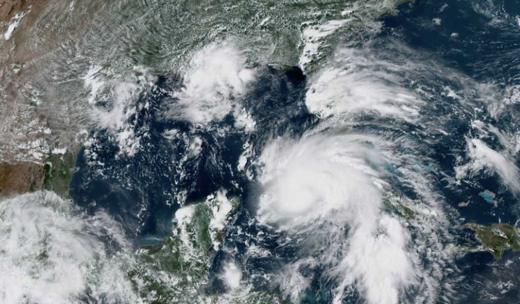
The National Hurricane Center announced Friday afternoon that Ida had reached hurricane strength as it churns its way into the Gulf of Mexico with its sights set on the northern Gulf Coast where it's expected to make landfall as a major hurricane on Sunday.
According to the NHC's latest update based on information gathered by an Air Force Hurricane Hunter, Ida has reached hurricane strength as it sweeps past Cuba. Ida is expected to lash Cuba with "life-threatening storm surge and hurricane conditions" later Friday and into the evening.
1:15 PM EDT: Data from an Air Force Reserve Hurricane Hunter aircraft indicate that #Ida has strengthened to a hurricane, with maximum sustained winds of 75 mph. Tropical storm conditions are occurring on Cayo Largo, Cuba https://t.co/tW4KeFW0gB pic.twitter.com/aYXq5lRDq1
— National Hurricane Center (@NHC_Atlantic) August 27, 2021
As Ida works its way through the Gulf of Mexico, warm water temperatures set it up to continue gaining strength to pose a serious threat to the United States' Gulf Coast as a major hurricane. According to the National Hurricane Center's most recent update, Hurricane Ida will bring potentially deadly storm surge, winds, and rainfall:
The risk of life-threatening storm surge inundation is increasing along the coasts of Louisiana, Mississippi, and Alabama. Inundation of 7 to 11 feet above ground level is possible within the area from Morgan City, Louisiana, to Ocean Springs, Mississippi, including Lake Borgne.
Ida is expected to be a dangerous major hurricane when it reaches the northern Gulf Coast on Sunday, and the risk of hurricane-force winds continues to increase, especially along portions of the Louisiana coast, including metropolitan New Orleans. Potentially devastating wind damage could occur where the core of Ida moves onshore.
Ida is likely to produce heavy rainfall later Sunday into Monday across the central Gulf Coast from southeast Louisiana to coastal Mississippi and Alabama, as well as the Lower Mississippi Valley, resulting in considerable flash, urban, small stream, and riverine flooding.
Recommended

Fox News Channel senior meteorologist Janice Dean says mandatory evacuations for the areas under immediate threat could be issued as soon as Friday afternoon due to the threat Ida poses.
A stronger Ida now making landfall just west of New Orleans which is not good news. Mandatory evacuations are coming this afternoon. pic.twitter.com/05M4Jrq3Vq
— Janice Dean (@JaniceDean) August 27, 2021
A lot of major headlines in the news, but this deserves your attention as well. A major hurricane coming this close to New Orleans Sunday/Monday is a very big deal. Still some time to fine tune the forecast, but Louisiana needs to be on high alert. pic.twitter.com/sWvbXF20L9
— Janice Dean (@JaniceDean) August 27, 2021
The threat of a major hurricane making landfall Sunday near New Orleans is reminding many of Hurricane Katrina — a storm that made landfall in the region at Category 5 strength on the same date 16 years ago.
I think there is now a good possibility #Ida may make landfall as a Category 4 closer to New Orleans.
— Michael Ferragamo (@FerragamoWx) August 27, 2021
The most recent storm I can really think of that made landfall at this projected strength near New Orleans is... well... Katrina. pic.twitter.com/6qqNPZE2i7
Tropical Storm #Ida is expected to rapidly intensify in the Gulf of Mexico and make landfall near New Orleans on Sunday — the 16th anniversary of Hurricane Katrina — as a major hurricane.
— Currently (@currently) August 27, 2021
This storm is the real deal. pic.twitter.com/SlEFYfydPT


Join the conversation as a VIP Member