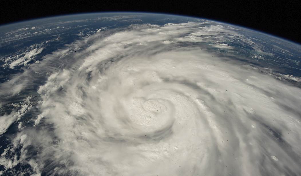
Earlier this afternoon, Hurricane Ian, upgraded to a major category four storm, made landfall in Cayo Costa, Florida, near Captiva and Sanibel—two neighboring islands that are being pounded by this ferocious storm as we speak. The storm surge is expected to be astounding at eight-to-twelve feet. Sanibel is only three feet above sea level. I pray that those in the Fort Myers area evacuated as this surge, according to the experts, is unsurvivable. The latest figures have at least 524,000 Floridians without power, which is expected to rise. As we published this post, that number has soared past one million. Power outages are expected to last days, if not weeks, due to the projected amount of damage from Ian. Spencer wrote about the initial images from the storm as Ian approached the state.
BREAKING: Hurricane #Ian has made landfall near Cayo Costa, Florida. Tune to The Weather Channel for all the latest details.https://t.co/wakMfwSvUD
— The Weather Channel (@weatherchannel) September 28, 2022
The most severe storm surge was forecast for the southwestern portion of the Florida coast. Storm surge, the rise in water generated by strong winds pushing ocean water ashore, can be one of a hurricane’s most deadly and destructive features. https://t.co/9YD762hJem pic.twitter.com/WyZpZE6nER
— The New York Times (@nytimes) September 28, 2022
In Punta Gorda, winds reached a devastating 124 miles per hour. The hellacious winds will undoubtedly cause power lines to collapse and transformers to be damaged, which is why the Florida Department of Highway Safety and Motor Vehicles issued a warning for residents to remain inside.
Do not go outside. Do not walk around. Do not go over/under downed power lines. Do not go through floodwaters.
— FLHSMV (@FLHSMV) September 28, 2022
Do be safe. https://t.co/kUZUoATHOp
Most stations down/offline now around Fort Myers but Punto Gorda reporting a gust up to 124mph. #Ian pic.twitter.com/0yupUJiXmF
— Eric Fisher (@ericfisher) September 28, 2022
NBC 2 Southwest Florida was in contact with a family whose home was engulfed by the storm surge. Their status is unknown since the connection was lost, but local reporters advised the anxious father to find any flotation device, any item in his house that he thinks could float and be prepared to head to the roof.
Recommended
Our @NBC2 team is live on air trying to help a family trapped in Fort Myers Beach. Water is up to the second floor and quickly rising.
— Kyla Galer (@kylagaler) September 28, 2022
Unfortunately the call dropped before they got to a safe location.
GET TO HIGHER GROUND. WE ARE NOT EVEN AT THE PEAK OF STORM SURGE. pic.twitter.com/KeI7rt57E2
As for the hurricane hunters collecting data from Ian as it approached the United States, some have called the flights the roughest of their careers. The New York Times spoke with Nick Underwood, who has flown into the eye of nearly 100 storms over his career. Underwood, a National Oceanic Atmospheric Administration aerospace engineer, noted that the lightning show within Ian was nothing he had ever seen before and that the eye itself, usually the calmest area for hurricanes, was exceptionally turbulent (via NYT):
Nick Underwood has flown into the eye of 76 storms over the past six years as an aerospace engineer for the National Oceanic Atmospheric Administration. His roughest flight so far? Early Wednesday, to the heart of Hurricane Ian.
“I’ve never seen so much lightning,” he said in a phone interview after landing in Houston.
Mr. Underwood described an exceptionally turbulent experience punching through Ian’s thick eye wall. Even inside the eye, which is usually the calmest part of the storm, he and the flight crew, technicians and scientists on the team were continually buffeted inside a Lockheed WP-3D Orion aircraft known as Kermit.
“We’re kind of used to the up-and-down, roller coaster feeling that you get, but in this case, there was just a lot of lateral movement,” he said. “It was a lot more unnerving.”
"The roughest flight of my career."
— ABC News (@ABC) September 28, 2022
Mattresses thrown from their bunks as hurricane hunters fly into Hurricane Ian. https://t.co/ybZtsLdOAA pic.twitter.com/nMyFdTanqi
In 2004, Hurricane Charley, another category four storm, swept into the Sunshine state on a similar path, but that was a fast-moving system, which blessedly limited the severity of the damage that still totaled nearly $17 billion. Ten people were killed. With Ian, it’s a larger storm it’s going to linger and inflict more damage.
This is wild.
— The Weather Channel (@weatherchannel) September 28, 2022
Hurricane #Ian made landfall in nearly the exact same spot #Charley did back in 2004.
However, these two storms are very different in critical ways. We're LIVE with more. pic.twitter.com/kryZJRLckB
Stay safe, Floridians. This one is going to be catastrophic.
Houses are wiped off their foundations and seen floating down streets in Fort Myers Beach as storm surge from Hurricane #Ian moves in.
— Zach Covey (@ZachCoveyTV) September 28, 2022
?? Cathy Haggins pic.twitter.com/Zw1IOXbgQY
Storm surge in Fort Myers, Florida is absolutely brutal right now.
— Scott Duncan (@ScottDuncanWX) September 28, 2022
Major hurricane Ian is currently equalling the 4th strongest hurricane to ever hit Florida.
This camera is 6ft above the ground btw
?? Via @mikebettespic.twitter.com/BDLZj33csP


Join the conversation as a VIP Member