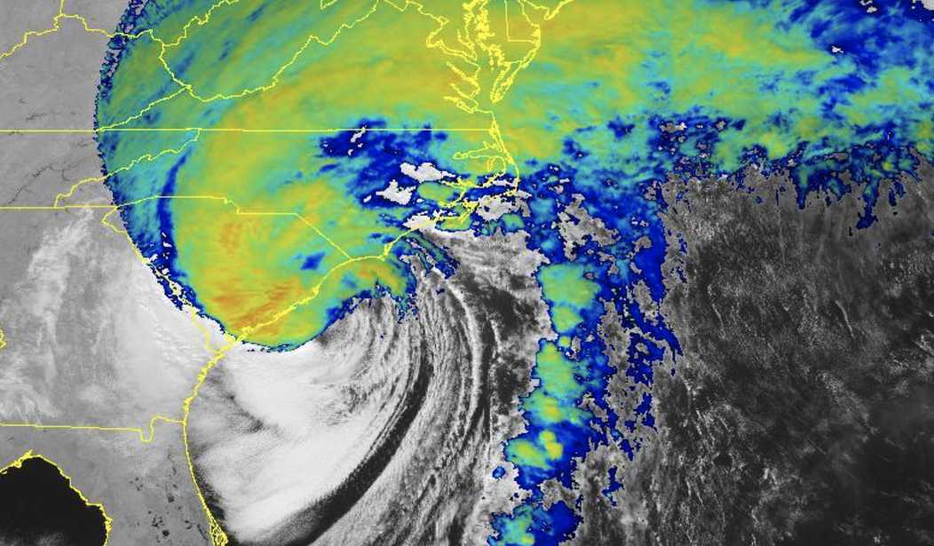
After carving a path of destruction across Florida earlier this week, Hurricane Ian restrengthened into a Category 1 storm while over the Atlantic before turning inland again to make landfall on Friday afternoon just after 2:15 p.m. in South Carolina between Charleston and Myrtle Beach.
In the latter, NOAA reported that water levels were more than five feet above normal high tide just before Ian made landfall — the third-highest water level on record there.
Hurricane Ian is nearing its final landfall along the South Carolina coast.@FoxNews Correspondent @MollyLineFNC is in Charleston with a look at current conditions.
— FOX Weather (@foxweather) September 30, 2022
Watch live on YouTube: https://t.co/6oqe9SAyaM #scwx pic.twitter.com/uQoY7bzb0B
Sadly, Cherry Grove is flooding again. Video via Megan Royster Nichols. #scwx #ncwx pic.twitter.com/xovRA6Qk3m
— Ed Piotrowski (@EdPiotrowski) September 30, 2022
Ian isn’t done wreaking havoc yet.
— Emilie Ikeda (@EmilieIkedaNBC) September 30, 2022
Conditions are rapidly deteriorating here in Charleston, SC, with the system’s second landfall potentially minutes away. @NBCNews pic.twitter.com/3titWFT5DV
#Hurricane #IAN Isle of Palms Connector Bridge #SouthCarolina #Charleston pic.twitter.com/iodpw21k91
— David Velez (@HurricaneXplore) September 30, 2022
Video of Myrtle Ave nr N Causeway following rescue. pic.twitter.com/0XyBOVpXYh
— Pawleys Island PD (@PawleysIslandPD) September 30, 2022
While less severe than what Florida saw from Ian, the hurricane brought storm surge, flash flooding, and powerful winds to South Carolina as videos show water pouring into neighborhood streets as trees whip around in the 80+ mph winds and piers get destroyed by roiling waves.
Recommended
Wow! The end of the Pawleys Island Pier in South Carolina has collapsed and is floating away.
— Rob Way (@RobWayTV) September 30, 2022
The American flag is still flying as Hurricane Ian barrels onshore.
??: Pawleys Island PD pic.twitter.com/rNJcmk61KM
Heavy rain, strong winds and surge inundating Cherry Grove. Video via Elizabeth Lowery. #scwx #ncwx pic.twitter.com/SsqXvl3J6y
— Ed Piotrowski (@EdPiotrowski) September 30, 2022
Storm surge from #Ian continues to worsen in Garden City Beach, South Carolina. #scwx Video by Jennifer Horne pic.twitter.com/jqjBuHjPI5
— Kaitlin Wright (@wxkaitlin) September 30, 2022
Front Street in Georgetown as Ian nears landfall @Live5News #hurricaineIan #chsnews #chswx pic.twitter.com/pb2A7eM9cD
— Rey Llerena (@ReyLlerenaTV) September 30, 2022
Before making landfall, Hurricane Ian's eyewall lashed South Carolina's coast with driving rain and whipping wind, triggering power outages as saturated ground and strong winds saw trees take down power lines. More than 150,000 customers in South Carolina are already without power while Ian's outer bands have already caused roughly 25,000 outages in North Carolina.
BIG WIND! Litchfield Beach, SC 12:05 pm. This is the eyewall! #scwx pic.twitter.com/iR1QpWzc85
— Peter Forister ?????? (@forecaster25) September 30, 2022
CHARLESTON, SC:
— Trooper Bob (@TrooperBob_SC) September 30, 2022
12:45pm: The wind is starting to peel back a part of this roof in downtown Charleston.
#??Ian @ABCNews4 pic.twitter.com/E5fVjb4ydj
Getting BLASTED on the South Carolina coast!! Sustained tropical storm force winds with gusts approaching hurricane force!
— Justin Buchinsky (@JBuchinskyWX) September 30, 2022
With @forecaster25 and @darin_deveauWX, 10:40am.#Ian pic.twitter.com/hMTuaCNNOQ
Eye wall of Ian now coming ashore with official landfall in a couple hours. A driving rain but the surf is incredible. Water has risen dramatically and will do so even after landfall. pic.twitter.com/VBpYH8sv4r
— Josh Wurster (@joshwurster_) September 30, 2022
This is a developing story and may be updated.


Join the conversation as a VIP Member