
Warning systems get the hearings. Flood maps and NFIP built the floodplain.
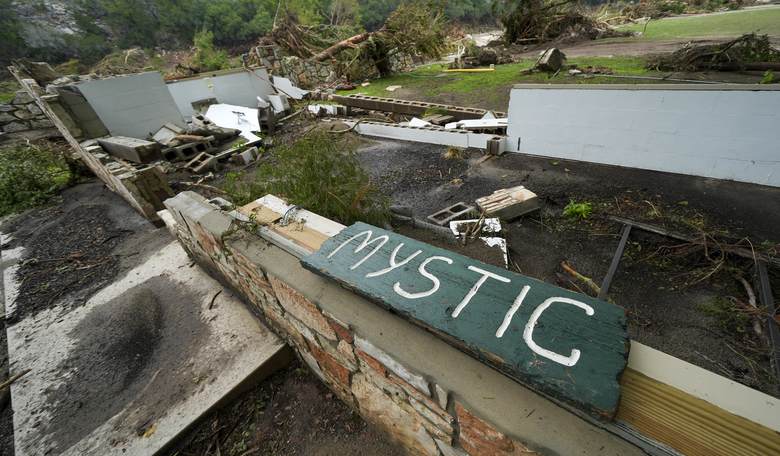
Early on July 4, 2025, in the Hill Country of Texas, the water poured from above, roared down from the hills, gushed into creeks, forks, and rivers, and then onto the floodplain, sweeping structures, humans, livestock, pets, semi-trucks, trailers, roads, trees, and anything else in its path away, FEMA flood maps, other federal government programs, and warning systems be damned. The floods killed at least 135 people. Twenty-seven campers and counselors died at Camp Mystic, which sat beside the Guadalupe River.
Apparently, the state flagged flash-flood potential on July 2. The National Weather Service put Kerr County under a flood watch on the afternoon of July 3. The first flash flood warning for Hunt and Camp Mystic went out at 1:14 A.M. on July 4. Some heeded them; others didn’t. Warning systems and evacuation plans were in place. Some of them worked; some of them may not have. Investigations regarding the warning systems and evacuation plans continue.
Contributing to the tragedy is the false sense of security two federal programs, both housed at FEMA, give to people occupying floodplains. These programs are flood mapping and national flood insurance.
I’ve discussed before the insolvent National Flood Insurance Program. In short, it’s a wealth-redistribution program moving money from all Americans to the ones living in coastal communities — many of them bearing the tell-tale markers of the well-heeled and erected since the inception of NFIP — where artificially low insurance premiums don’t cover the damage caused by natural disasters. The damage is often repetitive. Yes, your beach house can get knocked down by a storm, and you can build it again with NFIP reimbursement. The low premiums and repetitive losses cause the program to be in perpetual debt. Going into 2025, NFIP already owed the Treasury $20.5 billion. In February, it borrowed another $2 billion after Helene and Milton, and the tab sat at $22.5 billion. Congress has cancelled NFIP debt before — $16 billion after Harvey, Irma, and Maria. NFIP rests on the back of another federal program at FEMA: the flood mapping program.
In all my time at FEMA, I never found anyone who could explain to me in a single sentence what problem flood maps solved. When I asked, I was told by the most senior personnel at FEMA responsible for flood maps that the maps are not predictive; they are used as actuarial tools for insurance purposes. After the flood, the agency said the same thing in public:
“Flood maps are snapshots in time designed to show minimum standards for floodplain management and the highest risk areas for flood insurance. They are not predictions of where it will flood, and they don’t show where it has flooded before.” — FEMA, quoted by AP, 12 July 2025
Naively, I expected to hear something regarding public safety and precaution. I did not. I suspect the parents who lost their children the night of 4 July 2025 thought the same. Like me, they are likely aghast to find out the federal government’s main concern for flood mapping has nothing to do with safety or precaution.
Flood maps are developed by FEMA in coordination with local communities. The responsibility for the marks on the maps is diffuse; no single person or organization can be held accountable for what is or is not delineated on a FEMA flood map. That’s not by design; it’s simply how bureaucracy works. It’s survival. From what I saw working in the federal government and leading two separate federal agencies, survival is paramount. I’ve never once heard a single federal employee mention the best interests of the American people. I’ve heard hundreds, if not thousands, speak of the necessity of increased funding, expanding the scope of their mission, and adding to the size of their agency.
FEMA flood maps are subject to challenge and appeal. It happens often. The process of changing the maps is a collective effort; therefore, when tragedy strikes, it’s difficult to determine at what point too great a risk was assumed and by whom. Afterward, it’s easier to place blame on proximate causes such as failure of emergency warning systems and evacuation plans. But short of a scream, there is no failsafe emergency warning system, and even the scream can be too late or a false alarm. Warning systems sometimes fail due to human error, such as failure to pass the warning, heeding the warning, or not realizing a warning should be passed at all. The deeper cause of fatal flooding is the series of decisions that lead to building in the floodplain; both NFIP and flood maps influence these decisions.
While at FEMA, I found many solutions where the problem to be solved by the solution was not well understood. Therefore, the solution often missed the mark. What problem flood maps solved was an item on my list left unfinished when I resigned. Since I never got that chance for flood mapping while at FEMA, today I would suggest: Without flood maps, there is no tangible analysis to base approval or denial for building in floodplains.
If that’s even close, then FEMA needs the most up-to-date flood map capability available; it’s not apparent they have it. What’s worse, my problem statement confirms flood maps have nothing to do with safety or precaution. No federal spokesperson, especially not FEMA’s frightening talking head, will tell the public that. Instead, they will simply repeat the mantra: flood maps are not meant to be predictive; they are actuarial tools for insurance purposes. With the program as it is, accountability for mistakes and errors resulting in fatalities cannot be determined, since when disaster strikes, safety and precaution are not the concern of flood mapping at FEMA. Even if safety and precaution were problems to be solved by FEMA flood maps, the accountability for FEMA flood maps is so diffuse that no single person or office at the agency can be held responsible; if enough people are guilty, nobody is guilty. Lack of accountability is a government-wide problem. Yet I suggest, until that problem is solved, and it’s unlikely it ever will be, using FEMA flood maps is perilous.
Camp Mystic has been on site beside the Guadalupe River since 1926. FEMA put the camp in a Special Flood Hazard Area on the 2011 Kerr County flood map. People associated with the camp then challenged that line. FEMA granted the appeals: 15 buildings came off the map in 2013, another 15 in 2019 and 2020, most of those at the Cypress Lake expansion. It took bureaucrats at the federal, state, and local level to review and approve those maps along the Guadalupe. No single office or person is guilty. Once again, that’s not by design; it’s survival. Because of federal programs such as national flood insurance and flood maps, development in floodplains will continue; there will be more fatalities regardless of the warning systems put in place.
When I testified before Congress regarding the tragedy in Texas, nobody asked me about flood maps and why the lines on the maps had been changed to accommodate more buildings at Camp Mystic, and what problems flood maps solved if they could not solve the problem of a catastrophe such as the 2025 Texas flood. Instead, they focused on gotcha questions which, for the most part, I outmaneuvered. I was waiting for them to home in on the right target. My answer was in my notes. Their line of questioning about the tragedy told me they didn’t know enough to be asking questions, or they were more focused on stumping me for a news headline.
In paying respect to the children and all others who died during the Texas flood of July 2025, we should look beyond the culprit of warning systems and address the deep causes of such a tragedy. Otherwise, what happened in Texas Hill Country will happen again.